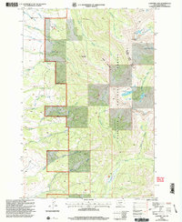
2000 Map of Campfire Lake
USGS Topo · Published 2005About this map
Gallatin National Forest encompasses the high country of the Big Timber Ranger District and Livingston Ranger District in this 2000 revision. The map details a complex drainage network where the Shields River and Sunlight Creek carve through the mountain landscape near Bald Ridge. Glacial activity is evident in the cluster of high-elevation water bodies, including Campfire Lake, Moose Lake, and the remote Dead Horse Lakes tucked beneath steep ridgelines. Geologists and outdoorsmen can trace the various forks of Elk Creek and Daisy Creek as they descend from prominent summits like Sugarloaf Mountain and Sunlight Peak. This survey represents the area's wilderness character at the turn of the 21st century, showing the intricate topography before modern digital mapping became the standard.
Find a feature on this map
36 named features on this map. Tap any name to fly to it.
Don’t see what you’re looking for? This feature index may not catch every label — zoom into the map to look around manually.
Map Details
Editions of this 2000 Campfire Lake Map
This is the sole edition of this map. No revisions or reprints were ever made.
Other maps of this area

1886 · Little Belt Mts.
USGS Topo · 1:250,000

1891 · Livingston
USGS Topo · 1:250,000

1893 · Livingston
USGS Topo · 1:250,000

1894 · Little Belt Mts.
USGS Topo · 1:250,000

1897 · Little Belt Mts.
USGS Topo · 1:250,000

1898 · Little Belt Mts.
USGS Topo · 1:250,000

1902 · Little Belt Mts.
USGS Topo · 1:250,000

1947 · Bozeman
USGS Topo · 1:250,000

1948 · Bozeman
USGS Topo · 1:250,000

1948 · White Sulphur Springs
USGS Topo · 1:250,000