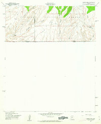
1958 Map of Campini Mesa
USGS Topo · Published 1963About this map
The United States-Mexico border defines the southern edge of this 1958 survey, where the rugged terrain of the Coronado National Forest meets the international boundary at Arizona-Sonora. High-desert ranching life is centered around isolated outposts like the Bercich Ranch and Lone Mountain Ranch, connected by the winding road through Sunnyside. The landscape is dominated by the broad Campini Mesa and a series of dramatic drainages including Bodie Canyon, Sunnyside Canyon, and School Canyon. This map records the precise boundary line between Santa Cruz and Cochise Counties as it traverses the high ridges, providing a clear view of the complex topography and water sources like Joaquin Creek that sustained this remote cattle country during the mid-twentieth century.
Find a feature on this map
17 named features on this map. Tap any name to fly to it.
Don’t see what you’re looking for? This feature index may not catch every label — zoom into the map to look around manually.
Map Details
Editions of this 1958 Campini Mesa Map
3 editions found
Other maps of this area

1905 · Nogales
USGS Topo · 1:125,000

1914 · Hereford
USGS Topo · 1:125,000

1922 · Sunnyside
USGS Topo · 1:62,500

1932 · Lochiel
USGS Topo · 1:62,500

1938 · Sunnyside
USGS Topo · 1:62,500

1948 · Canelo Pass
USGS Topo · 1:24,000

1948 · Huachuca Peak
USGS Topo · 1:24,000

1948 · Miller Peak
USGS Topo · 1:24,000

1948 · Sunnyside SE
USGS Topo · 1:24,000
1948 · Sunnyside SW
USGS Topo · 1:24,000