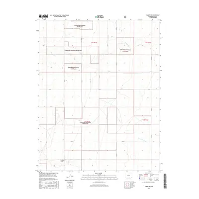
2016 Map of Campo NW
USGS Topo · Published 2016About this map
Comanche National Grassland dominates this corner of Baca County, where public lands are interwoven with private holdings in a distinct checkerboard pattern. The landscape is defined by the drainage of Sand Arroyo Cr and the N Fork Cimarron River, which cuts across the southeastern portion of the map. This area represents the high plains environment of southeastern Colorado, where the grid of county roads, such as Co Rd 21 and Co Rd T, provides the primary structure for the remote ranching and agricultural community. For those tracing local history or genealogy, the Lone Star Cem serves as a significant landmark, a quiet marker of the families who settled this open country in earlier generations.
Find a feature on this map
23 named features on this map. Tap any name to fly to it.
Don’t see what you’re looking for? This feature index may not catch every label — zoom into the map to look around manually.
Map Details
Editions of this 2016 Campo NW Map
This is the sole edition of this map. No revisions or reprints were ever made.
Other maps of this area

1891 · Springfield
USGS Topo · 1:125,000

1893 · Springfield
USGS Topo · 1:125,000

1955 · La Junta
USGS Topo · 1:250,000

1958 · La Junta
USGS Topo · 1:250,000

1968 · La Junta
USGS Topo · 1:250,000

1978 · Edler
USGS Topo · 1:24,000

1978 · Pritchett
USGS Topo · 1:24,000

1978 · Springfield SW
USGS Topo · 1:24,000
1978 · Campo SW
USGS Topo · 1:24,000

1978 · Campo NE
USGS Topo · 1:24,000