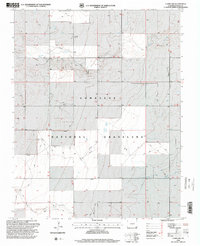
1996 Map of Campo NW
USGS Topo · Published 2000About this map
Comanche National Grassland dominates this section of the high plains in Baca County, where the landscape is defined by the ephemeral drainage of Sand Arroyo and the deeper cut of Ute Canyon. This 1996 revision by the USDA Forest Service highlights a region where land use and preservation are closely linked, showing the complex boundary patterns between public grassland and private inholdings. Genealogists and local historians will find the solitary Lone Star Cem located in the northern reaches, a poignant marker of early homesteading efforts in this arid environment. The southern edge of the map is defined by the North Fork Cimarron River, which provides a vital water source for the region's ranching economy. The map also meticulously traces an extensive network of pipelines and four-wheel-drive trails, reflecting the modern industrial and recreational infrastructure overlaying the traditional cattle-grazing landscape.
Find a feature on this map
6 named features on this map. Tap any name to fly to it.
Don’t see what you’re looking for? This feature index may not catch every label — zoom into the map to look around manually.
Map Details
Editions of this 1996 Campo NW Map
This is the sole edition of this map. No revisions or reprints were ever made.
Other maps of this area

1891 · Springfield
USGS Topo · 1:125,000

1893 · Springfield
USGS Topo · 1:125,000

1955 · La Junta
USGS Topo · 1:250,000

1958 · La Junta
USGS Topo · 1:250,000

1968 · La Junta
USGS Topo · 1:250,000

1978 · Edler
USGS Topo · 1:24,000

1978 · Pritchett
USGS Topo · 1:24,000

1978 · Springfield SW
USGS Topo · 1:24,000
1978 · Campo SW
USGS Topo · 1:24,000

1978 · Campo NE
USGS Topo · 1:24,000