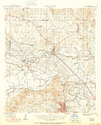
1948 Map of Campti
USGS Topo · Published 1950About this map
The Red River cuts a winding path through this central Louisiana landscape, defining the character of the Old Spanish Lake Lowlands and the complex network of surrounding bayous. In the late 1940s, the region was a patchwork of rural river communities, where the Louisiana and Arkansas and Texas and Pacific railroads provided essential transport links. The map reveals a high density of community landmarks, particularly country churches like Bethany Ch and New Bhelah Ch, alongside numerous local schools such as Zion Hill Sch and Bethlehem Sch.
Find a feature on this map
84 named features on this map. Tap any name to fly to it.
Don’t see what you’re looking for? This feature index may not catch every label — zoom into the map to look around manually.
Map Details
Editions of this 1948 Campti Map
2 editions found

Other maps of this area

1935 · Hagewood
USGS Topo · 1:31,680

1937 · Campti NE
USGS Topo · 1:31,680

1937 · Bermuda
USGS Topo · 1:31,680

1937 · Campti SE
USGS Topo · 1:31,680

1937 · Campti NW
USGS Topo · 1:31,680

1937 · Montgomery
USGS Topo · 1:62,500

1937 · Campti SW
USGS Topo · 1:31,680

1938 · Allen
USGS Topo · 1:31,680

1938 · Lake End
USGS Topo · 1:31,680

1942 · Many
USGS Topo · 1:62,500