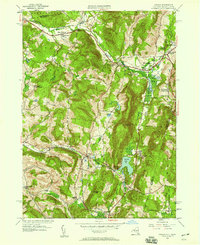
1946 Map of Canaan
USGS Topo · Published 1958About this map
The boundary between New York and Massachusetts defines the eastern edge of this 1940s landscape, where the town of New Lebanon and the village of Canaan serve as primary hubs for a network of valley settlements. The local economy and social structure are reflected in the concentration of educational and social institutions, including the Berkshire Industrial Farm and several rural schoolhouses like the District No 4 Sch and Frisbee Street Sch. The geography is shaped by the Kinderhook Creek and Stony Kill drainages, which historically provided the power and pathways for regional development.
Find a feature on this map
43 named features on this map. Tap any name to fly to it.
Don’t see what you’re looking for? This feature index may not catch every label — zoom into the map to look around manually.
Map Details
Editions of this 1946 Canaan Map
This is the sole edition of this map. No revisions or reprints were ever made.
Other maps of this area

1888 · Berlin
USGS Topo · 1:62,500

1888 · Pittsfield
USGS Topo · 1:62,500

1890 · Pittsfield
USGS Topo · 1:62,500

1890 · Berlin
USGS Topo · 1:62,500

1893 · Troy
USGS Topo · 1:62,500

1893 · Pittsfield
USGS Topo · 1:62,500

1894 · Berlin
USGS Topo · 1:62,500

1894 · Pittsfield
USGS Topo · 1:62,500

1895 · Troy
USGS Topo · 1:62,500

1897 · Pittsfield
USGS Topo · 1:62,500