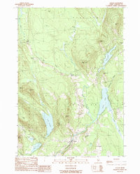
1989 Map of Canaan
USGS Topo · Published 1989About this map
Canaan serves as the central hub of this Somerset County landscape, where the town's geography is defined by a dense network of water bodies and prominent hills. To the east and west, large water features like Sibley Pond and Lake George anchor the terrain, while smaller pockets of water such as Oaks Pond and Round Pond dot the southern area. The land is characterized by numerous family-named peaks, including Jewell Hill, Foster Hill, and Nelson Hill, suggesting a history of local land ownership and homesteading.
Find a feature on this map
41 named features on this map. Tap any name to fly to it.
Don’t see what you’re looking for? This feature index may not catch every label — zoom into the map to look around manually.
Map Details
Editions of this 1989 Canaan Map
This is the sole edition of this map. No revisions or reprints were ever made.
Other maps of this area

1892 · Waterville
USGS Topo · 1:62,500

1913 · Skowhegan
USGS Topo · 1:62,500

1926 · Burnham
USGS Topo · 1:62,500

1930 · Pittsfield
USGS Topo · 1:48,000

1932 · Pittsfield
USGS Topo · 1:62,500

1933 · Pittsfield
USGS Topo · 1:62,500

1943 · Waterville
USGS Topo · 1:62,500

1948 · Bangor
USGS Topo · 1:250,000

1955 · Pittsfield
USGS Topo · 1:62,500

1955 · Skowhegan
USGS Topo · 1:62,500