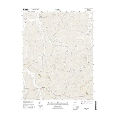
2016 Map of Cannel City
USGS Topo · Published 2016About this map
Cannel City and its surrounding communities in Wolfe, Morgan, and Magoffin counties are captured here in a transition from their industrial past to modern connectivity. The landscape is defined by its numerous family-named branches and forks, such as Halsey Fork Rd and Sellers-Phipps Branch Rd, which trace the narrow valleys between prominent elevations like Testerman Knob and Pilot Knob. The southern portion of the map is dominated by the Bert T Combs Mountain Pkwy, a modern engineering feat that cuts across the older settlement patterns of Helechawa and Lower Gillmore. These settlements, along with Saints Bottom and Caney, reflect a deeply rooted Appalachian geography where small clusters of homes and family cemeteries follow the intricate drainage patterns of the Cumberland Plateau foothills.
Find a feature on this map
80 named features on this map. Tap any name to fly to it.
Don’t see what you’re looking for? This feature index may not catch every label — zoom into the map to look around manually.
Map Details
Editions of this 2016 Cannel City Map
This is the sole edition of this map. No revisions or reprints were ever made.
Other maps of this area

1889 · Salyersville
USGS Topo · 1:125,000

1891 · Salyersville
USGS Topo · 1:125,000

1899 · Salyersville
USGS Topo · 1:125,000

1950 · Lenox
USGS Topo · 1:24,000

1951 · Cannel City
USGS Topo · 1:24,000

1951 · Landsaw
USGS Topo · 1:24,000

1951 · White Oak
USGS Topo · 1:24,000

1951 · Ezel
USGS Topo · 1:24,000

1951 · Hazel Green
USGS Topo · 1:24,000
1951 · Lenox
USGS Topo · 1:24,000