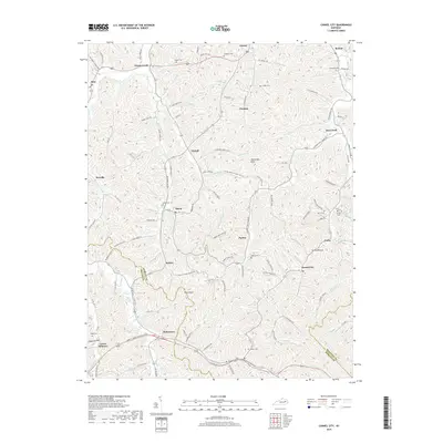
2019 Map of Cannel City
USGS Topo · Published 2019About this map
Cannel City and the surrounding hollows of Morgan Co and Wolfe Co define this detailed survey of the Cumberland Plateau's edge. The landscape is marked by a dense network of family-named cemeteries and small settlements like Helechawa, Nickell, and Grassy Creek that follow the winding paths of Caney Cr and Stacy Fork. The naming of Mining Br near Saints Bottom alludes to the region's industrial ties, while prominent terrain features like Testerman Knob and Pilot Knob provide fixed reference points for the area's intricate topography. Genealogists will find significant value in the documentation of numerous local burial sites, including Salem Cem, Ferguson Cem, and Morris Cem, many of which are tucked away on ridges like Bob Bolin Ridge. This documentation preserves the footprint of rural Kentucky life, where small post offices and family holdings have long dictated the local geography.
Find a feature on this map
134 named features on this map. Tap any name to fly to it.
Don’t see what you’re looking for? This feature index may not catch every label — zoom into the map to look around manually.
Map Details
Editions of this 2019 Cannel City Map
This is the sole edition of this map. No revisions or reprints were ever made.
Other maps of this area

1889 · Salyersville
USGS Topo · 1:125,000

1891 · Salyersville
USGS Topo · 1:125,000

1899 · Salyersville
USGS Topo · 1:125,000

1950 · Lenox
USGS Topo · 1:24,000

1951 · Cannel City
USGS Topo · 1:24,000

1951 · Landsaw
USGS Topo · 1:24,000

1951 · White Oak
USGS Topo · 1:24,000

1951 · Ezel
USGS Topo · 1:24,000

1951 · Hazel Green
USGS Topo · 1:24,000
1951 · Lenox
USGS Topo · 1:24,000