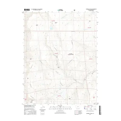
2016 Map of Cannibal Plateau
USGS Topo · Published 2016About this map
Slumgullion Earthflow and the Slumgullion Slide dominate the southern reach of this landscape, documenting a massive geologic movement within the Gunnison National Forest. This high-altitude terrain is defined by broad tablelands including the Cannibal Plateau and Calf Creek Plateau, separated by dramatic drops into Devils Canyon and Cañon Infierno. The network of primitive routes, such as the Cannibal Plateau Trail and Cebolla Trail, suggests a region primarily used for forest management and backcountry recreation. Water features are concentrated in the high basins, from the isolated Devils Lake to the Deer Lakes near Gardner Ridge. The drainages of Middle Fork Powderhorn Cr and Cebolla Cr carve through the plateaus, illustrating the erosive forces that have shaped this portion of Hinsdale County.
Find a feature on this map
37 named features on this map. Tap any name to fly to it.
Don’t see what you’re looking for? This feature index may not catch every label — zoom into the map to look around manually.
Map Details
Editions of this 2016 Cannibal Plateau Map
This is the sole edition of this map. No revisions or reprints were ever made.
Other maps of this area

1903 · Lake City
USGS Topo · 1:62,500

1905 · Lake City
USGS Topo · 1:62,500

1905 · San Cristobal
USGS Topo · 1:125,000

1907 · San Cristobal
USGS Topo · 1:125,000

1908 · Uncompahgre
USGS Topo · 1:125,000

1911 · Uncompahgre
USGS Topo · 1:125,000

1945 · Durango
USGS Topo · 1:250,000

1953 · Durango
USGS Topo · 1:250,000

1954 · Durango
USGS Topo · 1:250,000

1956 · Montrose
USGS Topo · 1:250,000