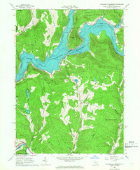
1965 Map of Cannonsville Reservoir
USGS Topo · Published 1967About this map
The Cannonsville Reservoir dominates this Delaware County landscape, illustrating a period of significant hydrological change as the West Branch Delaware River was harnessed for the NY City Water Supply. The map reveals the interplay between the massive new reservoir and the longstanding rural geography of the Catskills foothills. While the rising waters submerged former valley lands, high points like Speedwell Mtn remained as prominent landmarks overlooking the new shoreline. In the south, the Erie-Lackawanna RR cuts through the terrain near Sanford, providing a critical transit link that skirts the edge of the State Forest Preserve. Small clusters of settlement persist at Kelsey and Apex, while numerous quarries dot the hillsides, signifying the local extraction industries of the era. The presence of recreational sites such as Camp Hilltop and Kingswood Camp reflects the region's evolving role as a summer destination centered around features like Russell Lake and Hathaway Pond.
Find a feature on this map
39 named features on this map. Tap any name to fly to it.
Don’t see what you’re looking for? This feature index may not catch every label — zoom into the map to look around manually.
Map Details
Editions of this 1965 Cannonsville Reservoir Map
3 editions found
Other maps of this area

1920 · Long Eddy
USGS Topo · 1:62,500

1921 · Long Eddy
USGS Topo · 1:48,000

1923 · Long Eddy
USGS Topo · 1:62,500

1923 · Walton
USGS Topo · 1:48,000

1924 · Starrucca
USGS Topo · 1:48,000

1924 · Deposit
USGS Topo · 1:62,500

1925 · Walton
USGS Topo · 1:62,500

1926 · Deposit
USGS Topo · 1:62,500

1926 · Starrucca
USGS Topo · 1:62,500

1930 · Starrucca
USGS Topo · 1:48,000