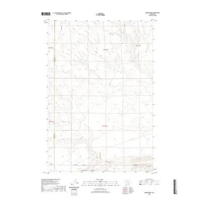
2020 Map of Canoe Ridge
USGS Topo · Published 2020About this map
Canoe Ridge and the deep drainage of Dead Canyon define this section of the Horse Heaven Hills along the boundary between Klickitat and Benton counties. The landscape is marked by the persistent flow of Glade Cr through the northeast corner, while the surrounding upland is carved by topographic features like Moore Canyon and the prominent Quarry Butte. A network of rural routes, including Canoe Ridge Rd and Sonova Rd, suggests the agricultural and industrial reach into these high elevations. Modern land use is evident through names such as 100 Circle Farms Rd, indicating the scale of irrigation and farming operations that have transformed this arid region. The map provides a clear view of the elevation changes and land divisions within townships such as t6n r24e, showing how the terrain dictates the layout of local infrastructure.
Find a feature on this map
16 named features on this map. Tap any name to fly to it.
Don’t see what you’re looking for? This feature index may not catch every label — zoom into the map to look around manually.
Map Details
Editions of this 2020 Canoe Ridge Map
This is the sole edition of this map. No revisions or reprints were ever made.
Other maps of this area

1906 · Blalock Island
USGS Topo · 1:125,000

1908 · Blalock Island
USGS Topo · 1:125,000

1915 · Prosser
USGS Topo · 1:125,000

1917 · Prosser
USGS Topo · 1:125,000

1953 · Pendleton
USGS Topo · 1:250,000

1953 · Walla Walla
USGS Topo · 1:250,000

1955 · Prosser SW
USGS Topo · 1:24,000

1956 · Pendleton
USGS Topo · 1:250,000

1958 · Walla Walla
USGS Topo · 1:250,000
1962 · Phinny Hill
USGS Topo · 1:24,000