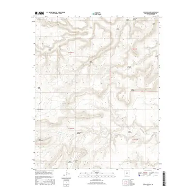
2017 Map of Canon Olguin
USGS Topo · Published 2017About this map
Arroyo Banco Quemado and the remote San Miguel Ranch Airport highlight the sparse human footprint in this corner of San Miguel County during the early 21st century. The landscape is defined by a complex network of erosional features, including the prominent Cañon Olguin, Cañon Santiago, and Cañon Sanchez. These deep drainages cut through the high tablelands of Mesa Huerfanita and Mesa Huerfana, illustrating the dramatic topographic relief typical of the region's plateau country. Waterways like Trementina Cr and Arroyo Hondo snake through the canyons, while a few designated routes such as CO RD C 56-A Corazon provide the only significant access through the breaks. The map captures a moment of modern ranching life where vast tracts of land are connected primarily by unpaved roads and private airstrips.
Find a feature on this map
30 named features on this map. Tap any name to fly to it.
Don’t see what you’re looking for? This feature index may not catch every label — zoom into the map to look around manually.
Map Details
Editions of this 2017 Canon Olguin Map
This is the sole edition of this map. No revisions or reprints were ever made.
Other maps of this area

1892 · Watrous
USGS Topo · 1:125,000

1892 · Corazon
USGS Topo · 1:125,000

1894 · Corazon
USGS Topo · 1:125,000

1894 · Watrous
USGS Topo · 1:125,000

1954 · Santa Fe
USGS Topo · 1:250,000

1958 · Santa Fe
USGS Topo · 1:250,000

1971 · Trujillo
USGS Topo · 1:24,000

1971 · Canon Olguin
USGS Topo · 1:24,000

1972 · Variadero
USGS Topo · 1:24,000
1972 · Maes
USGS Topo · 1:24,000