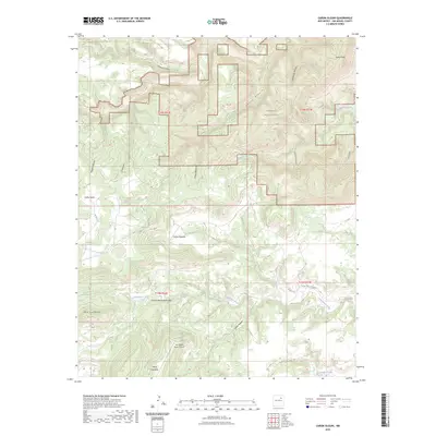
2023 Map of Canon Olguin
USGS Topo · Published 2023About this map
Sabinoso Wilderness dominates the northeastern landscape of this San Miguel County region, where complex canyon systems drain toward Trementina Creek. The topography is defined by significant landforms like Mesa Huerfanita and Mesa Huerfana, surrounded by a dense network of named drainages including Cañon Olguin, Cañon del Muerto, and Cañon Encierto. These deep incisions in the high plains indicate a highly eroded environment where water management and natural boundaries dictate land use. Human activity is centered around the San Miguel Ranch Airport and a series of rural routes such as Co RD C-51-A and CO RD C-56-A Corazon. The map reveals a remote ranching landscape where isolated water features like Lagartija Creek and Arroyo Hondo provide essential landmarks in a territory otherwise shaped by expansive mesas and winding arroyos like Arroyo Banco Quemado.
Find a feature on this map
28 named features on this map. Tap any name to fly to it.
Don’t see what you’re looking for? This feature index may not catch every label — zoom into the map to look around manually.
Map Details
Editions of this 2023 Canon Olguin Map
This is the sole edition of this map. No revisions or reprints were ever made.
Other maps of this area

1892 · Watrous
USGS Topo · 1:125,000

1892 · Corazon
USGS Topo · 1:125,000

1894 · Corazon
USGS Topo · 1:125,000

1894 · Watrous
USGS Topo · 1:125,000

1954 · Santa Fe
USGS Topo · 1:250,000

1958 · Santa Fe
USGS Topo · 1:250,000

1971 · Trujillo
USGS Topo · 1:24,000

1971 · Canon Olguin
USGS Topo · 1:24,000

1972 · Variadero
USGS Topo · 1:24,000
1972 · Maes
USGS Topo · 1:24,000