
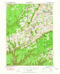
1942 Map of Canton
USGS Topo · Published 1958About this map
Canton serves as the central hub of this northern Pennsylvania landscape, situated where the valley of Lycoming Creek meets several mountain streams during the early 1940s. The region is defined by a dense network of rural infrastructure, including many neighborhood-level institutions such as Joe Hill Sch and the North Union Ch. The Pennsylvania railroad corridor follows the narrow valley floors, connecting small settlements like Grover and Alba to larger markets, while high-elevation areas like Ellenton Mtn remain largely undeveloped.
Find a feature on this map
82 named features on this map. Tap any name to fly to it.
Don’t see what you’re looking for? This feature index may not catch every label — zoom into the map to look around manually.
Map Details
Editions of this 1942 Canton Map
2 editions found
Other maps of this area

1900 · Tioga
USGS Topo · 1:62,500

1902 · Tioga
USGS Topo · 1:62,500

1921 · Trout Run
USGS Topo · 1:62,500

1923 · Trout Run
USGS Topo · 1:62,500

1925 · Blossburg
USGS Topo · 1:62,500

1927 · Eagles Mere
USGS Topo · 1:48,000

1927 · Blossburg
USGS Topo · 1:62,500

1930 · Warrensville
USGS Topo · 1:62,500

1931 · Troy
USGS Topo · 1:48,000

1932 · Eagle Mere
USGS Topo · 1:62,500