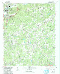
1992 Map of Canton
USGS Topo · Published 1993About this map
The Etowah River flows through the northern reaches of this Cherokee County landscape, passing the established community of Canton and its surrounding suburbs. By the early 1990s, the area reflects a mix of traditional crossroads and emerging residential growth, with neighborhoods branching off from historical thoroughfares like Brick Mill Road and Univeter Road. The infrastructure of the era is well-defined, featuring the Filtration Plant, a Lookout Tower, and the Louisville and Nashville railroad line following the river's bend.
Find a feature on this map
74 named features on this map. Tap any name to fly to it.
Don’t see what you’re looking for? This feature index may not catch every label — zoom into the map to look around manually.
Map Details
Editions of this 1992 Canton Map
This is the sole edition of this map. No revisions or reprints were ever made.
Other maps of this area

1890 · Suwanee
USGS Topo · 1:125,000

1890 · Cartersville
USGS Topo · 1:125,000

1891 · Cartersville
USGS Topo · 1:125,000

1894 · Suwanee
USGS Topo · 1:125,000

1896 · Cartersville
USGS Topo · 1:125,000

1907 · Acworth
USGS Topo · 1:62,500

1909 · Acworth
USGS Topo · 1:62,500

1926 · Tate
USGS Topo · 1:62,500

1928 · Tate
USGS Topo · 1:62,500

1947 · Waleska
USGS Topo · 1:62,500