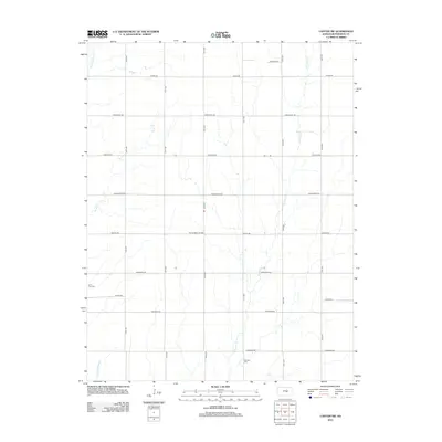
2012 Map of Canton SW
USGS Topo · Published 2012About this map
Running Turkey Cr and W Emma Cr carve winding paths through this agricultural landscape in McPherson County, defining the local topography long after the primary land division took place. The territory is organized by a rigid grid of roads, many bearing names that evoke the frontier history of the Kansas plains, such as Chisholm Rd, Comanche Rd, and Iron Horse Rd. Local history is anchored by the Lone Tree Cem and Meridian Cem, providing critical landmarks for genealogical research in this rural district. Subsurface activity is evidenced by the Spring Valley Oil Field located near Spring Valley Oil Field, signaling the continued importance of energy extraction alongside traditional prairie farming. Other waterways like Sand Cr and Black Kettle Cr drain the southern reaches of the quadrangle, where the terrain gently shifts near the intersections of numbered avenues.
Find a feature on this map
24 named features on this map. Tap any name to fly to it.
Don’t see what you’re looking for? This feature index may not catch every label — zoom into the map to look around manually.
Map Details
Editions of this 2012 Canton SW Map
This is the sole edition of this map. No revisions or reprints were ever made.
Other maps of this area

1889 · Newton
USGS Topo · 1:125,000

1891 · Hutchinson
USGS Topo · 1:125,000

1893 · Hutchinson
USGS Topo · 1:125,000

1894 · Newton
USGS Topo · 1:125,000

1955 · Hutchinson
USGS Topo · 1:250,000

1959 · Hutchinson
USGS Topo · 1:250,000

1965 · Goessel
USGS Topo · 1:24,000

1965 · Galva
USGS Topo · 1:24,000
1965 · Mc Pherson SE
USGS Topo · 1:24,000
1965 · Hesston
USGS Topo · 1:24,000