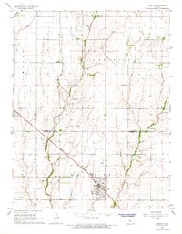
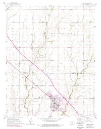
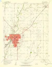
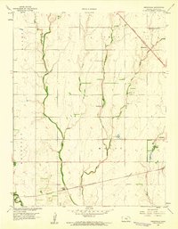
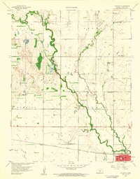
1965 Map of Hesston
USGS Topo · Published 1966About this map
Hesston anchors the southern landscape of this mid-1960s survey, a period when the town was defined by the presence of Hesston College and the Missouri Pacific railroad line. The surrounding countryside reveals a grid of rural life, marked by small landmarks like Meadowlark Sch and the Meridian Ch. A network of creeks, including Black Kettle Creek, Emma Creek, and West Emma Creek, drain the agricultural plains, while the northern sections show the influence of local industry via the Goessel Oil Field and scattered Oil Wells. The boundary between McPherson and Harvey Counties cuts across the center, highlighting the regional orientation of local farms. For genealogists, the map provides precise locations for the Freedom Cem and Meridian Cem, alongside specialized sites such as a Fish Hatchery and multiple landing strips.
Find a feature on this map
23 named features on this map. Tap any name to fly to it.
Don’t see what you’re looking for? This feature index may not catch every label — zoom into the map to look around manually.
Map Details
Editions of this 1965 Hesston Map
2 editions found
Other maps of this area

1889 · Newton
USGS Topo · 1:125,000

1891 · Hutchinson
USGS Topo · 1:125,000

1893 · Hutchinson
USGS Topo · 1:125,000

1894 · Newton
USGS Topo · 1:125,000

1955 · Hutchinson
USGS Topo · 1:250,000
1957 · Newton
USGS Topo · 1:24,000

1959 · Hutchinson
USGS Topo · 1:250,000
1959 · Zimmerdale
USGS Topo · 1:24,000
1959 · Halstead
USGS Topo · 1:24,000
1965 · Goessel
USGS Topo · 1:24,000