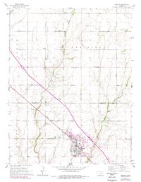
1965 Map of Hesston
USGS Topo · Published 1978About this map
Hesston serves as the hub of this Central Kansas landscape, where the campus of Hesston College stands alongside the Missouri Pacific railroad. The agricultural character of Meridian and Garden townships is clearly defined by a grid of farmsteads and rural institutions, including the Meadowlark Sch and Freedom Cem. The drainage of West Emma Creek and Middle Emma Creek shapes the local topography, while industrial layers appear through the Graber Oil Field Pipeline and scattered Oil Wells. The map captures the interface between the growing town and its agrarian roots, documenting the transition from small-scale ranching, such as the Weaver Ranch Airfield, to modern municipal developments like the local Golf Course and residential Trailer Parks.
Find a feature on this map
21 named features on this map. Tap any name to fly to it.
Don’t see what you’re looking for? This feature index may not catch every label — zoom into the map to look around manually.
Map Details
Editions of this 1965 Hesston Map
2 editions found
Other maps of this area

1889 · Newton
USGS Topo · 1:125,000

1891 · Hutchinson
USGS Topo · 1:125,000

1893 · Hutchinson
USGS Topo · 1:125,000

1894 · Newton
USGS Topo · 1:125,000

1955 · Hutchinson
USGS Topo · 1:250,000

1957 · Newton
USGS Topo · 1:24,000

1959 · Hutchinson
USGS Topo · 1:250,000
1959 · Zimmerdale
USGS Topo · 1:24,000
1959 · Halstead
USGS Topo · 1:24,000

1965 · Goessel
USGS Topo · 1:24,000