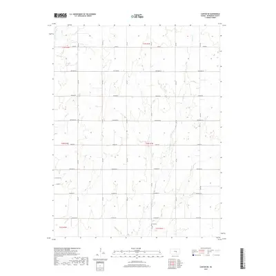
2018 Map of Canton SW
USGS Topo · Published 2018About this map
Lone Tree Cem and Meridian Cem stand as quiet markers of the rural landscape in this portion of McPherson County. The terrain is defined by a series of south-flowing drainage systems, most notably W Emma Cr and Sand Cr, which carve subtle valleys through the agricultural grid. This 2018 survey reveals a highly organized township and range system, where roads like Chisholm Rd, Iron Horse Rd, and Cimarron Rd follow section lines and carry names that evoke the region's historic cattle trails and pioneer history. The presence of Black Kettle Cr in the southwest corner and Running Turkey Cr in the northwest underscores the importance of local water sources to the surrounding prairie farms, maintaining a pattern of land use that has persisted for generations.
Find a feature on this map
27 named features on this map. Tap any name to fly to it.
Don’t see what you’re looking for? This feature index may not catch every label — zoom into the map to look around manually.
Map Details
Editions of this 2018 Canton SW Map
This is the sole edition of this map. No revisions or reprints were ever made.
Other maps of this area

1889 · Newton
USGS Topo · 1:125,000

1891 · Hutchinson
USGS Topo · 1:125,000

1893 · Hutchinson
USGS Topo · 1:125,000

1894 · Newton
USGS Topo · 1:125,000

1955 · Hutchinson
USGS Topo · 1:250,000

1959 · Hutchinson
USGS Topo · 1:250,000

1965 · Goessel
USGS Topo · 1:24,000

1965 · Galva
USGS Topo · 1:24,000
1965 · Mc Pherson SE
USGS Topo · 1:24,000
1965 · Hesston
USGS Topo · 1:24,000