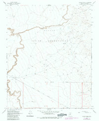
1968 Map of Canyon Diablo
USGS Topo · Published 1983About this map
Canyon Diablo snakes through this high desert landscape, defining a rugged geography that historically separated the Navajo Indian Reservation from the lands to the south. Along the canyon's edge, the map records evidence of early habitation and passage, including clusters of Ruins and a singular Ruin. The arrival of industrial transport is marked by the presence of the Atchison Topeka and Santa Fe railroad, which cuts across the southern portion of the quadrangle. Near the tracks and the canyon rim, a site labeled simply as Graves suggests the human toll and the isolated history of this arid crossing. The infrastructure of the steam era or ranching is further evidenced by a Water Tank, vital for sustaining life and locomotive travel in this water-scarce corner of Coconino County.
Find a feature on this map
8 named features on this map. Tap any name to fly to it.
Don’t see what you’re looking for? This feature index may not catch every label — zoom into the map to look around manually.
Map Details
Editions of this 1968 Canyon Diablo Map
2 editions found
Other maps of this area

1883 · Tusayan
USGS Topo · 1:250,000

1886 · Tusayan
USGS Topo · 1:250,000

1886 · San Francisco Mtns
USGS Topo · 1:250,000

1891 · San Francisco Mtns
USGS Topo · 1:250,000

1894 · San Francisco Mtns
USGS Topo · 1:250,000

1899 · San Francisco Mtns
USGS Topo · 1:250,000

1947 · Flagstaff
USGS Topo · 1:250,000

1954 · Flagstaff
USGS Topo · 1:250,000

1955 · Winslow 2 SW
USGS Topo · 1:24,000

1955 · Leupp
USGS Topo · 1:62,500