
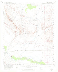
1955 Map of Leupp
USGS Topo · Published 1959About this map
The Navajo Indian Reservation landscape is defined here by the confluence of major ephemeral drainage systems and the prominent escarpments of Newberry Mesa. In the mid-1950s, the settlement of Leupp serves as a focal point near the Little Colorado River, supported by local infrastructure like the Landing Field and a series of water management features including a Dike and Levee. Further north, the Tolani Lake Day School stands as a significant institutional landmark at the junction of several desert tracks and washes.
Find a feature on this map
23 named features on this map. Tap any name to fly to it.
Don’t see what you’re looking for? This feature index may not catch every label — zoom into the map to look around manually.
Map Details
Editions of this 1955 Leupp Map
2 editions found
Other maps of this area

1883 · Tusayan
USGS Topo · 1:250,000

1886 · Tusayan
USGS Topo · 1:250,000

1886 · San Francisco Mtns
USGS Topo · 1:250,000

1891 · San Francisco Mtns
USGS Topo · 1:250,000

1894 · San Francisco Mtns
USGS Topo · 1:250,000

1899 · San Francisco Mtns
USGS Topo · 1:250,000

1947 · Flagstaff
USGS Topo · 1:250,000

1954 · Winslow
USGS Topo · 1:62,500

1954 · Winslow 4 NW
USGS Topo · 1:24,000

1954 · Flagstaff
USGS Topo · 1:250,000