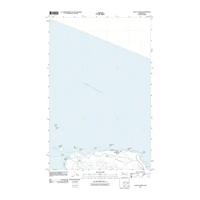
2011 Map of Cape Flattery
USGS Topo · Published 2011About this map
Cape Flattery marks the northwesternmost point of the contiguous United States, where the rocky coastline meets the Strait of Juan de Fuca. This coastal survey documents the intricate geography of the Makah Indian Reservation, highlighting the cultural and navigational importance of landmarks like the Cape Flattery Lighthouse on Tatoosh Island. The terrain is characterized by dramatic sea stacks and formations such as Fuca Pillar, Mushroom Rock, and the distinctive Hole-in-the Wall. Small coastal settlements including Midway and Classet are linked by the Cape Loop Rd, while the eastern edge of the map reaches toward the waters of Neah Bay. Notable water features like Titacoclos Falls and the secluded Warmhouse Beach illustrate the interaction between the land and the Pacific, providing a detailed record of this maritime boundary at the start of the 2010s.
Find a feature on this map
27 named features on this map. Tap any name to fly to it.
Don’t see what you’re looking for? This feature index may not catch every label — zoom into the map to look around manually.
Map Details
Editions of this 2011 Cape Flattery Map
This is the sole edition of this map. No revisions or reprints were ever made.
Other maps of this area

1938 · Cape Flattery
USGS Topo · 1:62,500

1953 · Cape Flattery
USGS Topo · 1:250,000
1957 · Cape Flattery
USGS Topo · 1:62,500

1963 · Cape Flattery
USGS Topo · 1:250,000
1984 · Makah Bay
USGS Topo · 1:24,000
1984 · Neah Bay
USGS Topo · 1:24,000
1984 · Waadah Island
USGS Topo · 1:24,000
1984 · Cape Flattery
USGS Topo · 1:24,000
1986 · Cape Flattery
USGS Topo · 1:100,000
2011 · Neah Bay
USGS Topo · 1:24,000