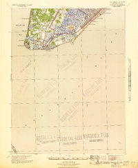
1941 Map of Cape May
USGS Topo · Published 1941About this map
The southern tip of New Jersey is documented here at the onset of the 1940s, a landscape defined by the coastal resorts of Cape May and the barrier island communities of Wildwood and Wildwood Crest. The map reveals a highly developed shoreline where maritime infrastructure and naval preparations are evident, notably at the U. S. Naval Res near Sewell Pt and the U. S. C. G. Docks. Inland, the area transitions from established settlements like Cold Spring and Erma to the extensive marshlands and thoroughfares of Jarvis Sound and Taylor Sound. Transport links are critical to the region's character, shown via the Reading Lines railroad and the Toll Bridge connecting the Cape to the mainland. The presence of Schellenger Landing and various piers, including the Municipal Pier, highlights the era's reliance on both rail and water for commerce and tourism.
Find a feature on this map
33 named features on this map. Tap any name to fly to it.
Don’t see what you’re looking for? This feature index may not catch every label — zoom into the map to look around manually.
Map Details
Editions of this 1941 Cape May Map
This is the sole edition of this map. No revisions or reprints were ever made.
Other maps of this area

1884 · Sea Isle
USGS Topo · 1:62,500

1888 · Cape May
USGS Topo · 1:62,500

1888 · Dennisville
USGS Topo · 1:62,500

1888 · Sea Isle
USGS Topo · 1:62,500

1890 · Maurice Cove
USGS Topo · 1:62,500

1891 · Maurice Cove
USGS Topo · 1:62,500

1893 · Cape May
USGS Topo · 1:62,500

1894 · Dennisville
USGS Topo · 1:62,500

1894 · Sea Isle
USGS Topo · 1:62,500

1898 · Cape May
USGS Topo · 1:62,500