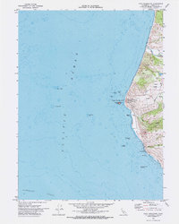
1969 Map of Cape Mendocino
USGS Topo · Published 1974About this map
The westernmost point of California at Cape Mendocino is meticulously detailed in this survey, showcasing the maritime hazards and coastal infrastructure of the late 1960s. The coastline is dominated by the U.S. Coast Guard Reservation and the historic Cape Mendocino Lighthouse, which guarded a treacherous stretch of the Pacific Ocean including Blunts Reef and The Great Break. Inland, the landscape rises sharply toward Cape Ridge, where small settlements and rural landmarks like Ocean House and Cape Ranch are situated along the Petrolia 8 Mi. Road.
Find a feature on this map
37 named features on this map. Tap any name to fly to it.
Don’t see what you’re looking for? This feature index may not catch every label — zoom into the map to look around manually.
Map Details
Editions of this 1969 Cape Mendocino Map
This is the sole edition of this map. No revisions or reprints were ever made.
Other maps of this area

1916 · Cape Fortunas
USGS Topo · 1:62,500

1921 · Cape Mendocino
USGS Topo · 1:62,500

1943 · Ferndale
USGS Topo · 1:62,500

1949 · Eureka
USGS Topo · 1:250,000

1950 · Cape Mendocino
USGS Topo · 1:62,500

1951 · Cape Mendocino
USGS Topo · 1:62,500

1951 · Ferndale
USGS Topo · 1:62,500

1958 · Eureka
USGS Topo · 1:250,000
1958 · Eureka
USGS Topo · 1:250,000
1959 · Ferndale
USGS Topo · 1:24,000