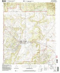
2004 Map of Capitan
USGS Topo · Published 2006About this map
Smokey Bear Historical Park sits at the heart of Capitan, New Mexico, marking a landscape defined by forest service history and cattle ranching. This early 21st-century record shows the transition from the village center out into the Lincoln National Forest, where the topography rises toward the Capitan Mountains. The drainage of Salado Creek and Oso Creek shapes the local valley, while established family holdings like the Robinson Ranch, Golder Ranch, and Martin Ranch illustrate the area's rural settlement pattern.
Find a feature on this map
43 named features on this map. Tap any name to fly to it.
Don’t see what you’re looking for? This feature index may not catch every label — zoom into the map to look around manually.
Map Details
Editions of this 2004 Capitan Map
This is the sole edition of this map. No revisions or reprints were ever made.
Other maps of this area

1934 · Capitan
USGS Topo · 1:48,000

1935 · Capitan Mountains
USGS Topo · 1:48,000

1937 · Capitan
USGS Topo · 1:62,500

1940 · Capitan Mountains
USGS Topo · 1:62,500

1955 · Roswell
USGS Topo · 1:250,000

1958 · Roswell
USGS Topo · 1:250,000

1961 · Lincoln
USGS Topo · 1:62,500

1962 · Roswell
USGS Topo · 1:250,000

1963 · Fort Stanton
USGS Topo · 1:24,000

1963 · Angus
USGS Topo · 1:24,000