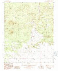
1990 Map of Captain Davis Mountain
USGS Topo · Published 1990About this map
Ortiz Mountains mineral wealth is evident across this landscape, where mining operations and remote outposts define the character of the Santa Fe high country. The northwestern corner reveals the industrial legacy of the Dolores Mine and its associated Tailings, while the Ortiz Mine and a nearby Quarry indicate the area's geological importance. Settlement is sparse, represented by the isolated Bullmill Camp and various water sources critical for high-altitude endurance, such as Peach Spring and Cañamo Spring.
Find a feature on this map
27 named features on this map. Tap any name to fly to it.
Don’t see what you’re looking for? This feature index may not catch every label — zoom into the map to look around manually.
Map Details
Editions of this 1990 Captain Davis Mountain Map
This is the sole edition of this map. No revisions or reprints were ever made.
Other maps of this area

1892 · San Pedro
USGS Topo · 1:125,000

1894 · Lamy
USGS Topo · 1:125,000

1954 · San Pedro
USGS Topo · 1:24,000

1954 · Santa Fe
USGS Topo · 1:250,000

1956 · Edgewood
USGS Topo · 1:62,500

1958 · Santa Fe
USGS Topo · 1:250,000

1958 · Albuquerque
USGS Topo · 1:250,000

1960 · Stanley
USGS Topo · 1:62,500

1961 · Madrid
USGS Topo · 1:62,500

1962 · Albuquerque
USGS Topo · 1:250,000