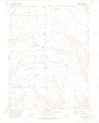
1974 Map of Carbonate
USGS Topo · Published 1978About this map
Carbonate sits atop a high plateau in the White River National Forest, characterized by a network of high-altitude lakes and ephemeral drainages. The landscape is defined by the prominent Quartzite Ridge, reaching its height at Quartzite Baxter Peak, and open clearings like Elbow Park and Crane Park. This 1970s survey documents a wilderness area where transportation is limited almost exclusively to a complex system of Jeep Trails and Pack Trails, indicating the area's use for remote recreation and livestock management, as seen at Grizzly Cow Camp. Several Prospects near Monument Lake point to small-scale mineral exploration history. Water resources are abundant, ranging from named springs like Hillside Spring to significant high-country basins including White Owl Lake, Ute Lake, and Yellow Lake.
Find a feature on this map
38 named features on this map. Tap any name to fly to it.
Don’t see what you’re looking for? This feature index may not catch every label — zoom into the map to look around manually.
Map Details
Editions of this 1974 Carbonate Map
3 editions found
Other maps of this area

1927 · Glenwood Springs
USGS Topo · 1:125,000

1930 · Glenwood Springs
USGS Topo · 1:125,000

1957 · Leadville
USGS Topo · 1:250,000

1959 · Leadville
USGS Topo · 1:250,000

1960 · Leadville
USGS Topo · 1:250,000

1961 · Shoshone
USGS Topo · 1:24,000

1961 · Glenwood Springs
USGS Topo · 1:24,000

1962 · Leadville
USGS Topo · 1:250,000

1962 · Storm King Mountain
USGS Topo · 1:24,000

1964 · Leadville
USGS Topo · 1:250,000