
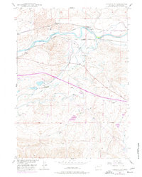
1949 Map of Careyhurst
USGS Topo · Published 1966About this map
The North Platte River carves through the landscape of Converse County, Wyoming, providing the essential water source for early agricultural and industrial operations in this high plains region. Following the river's northern bank, the Chicago and Northwestern railroad links small rail stops and ranching hubs like Welch, Fletcher, and Clayton. The area’s reliance on water management is evident through the presence of the Quincy Ditch and West Side Ditch, which redirect river flow to support local livestock and agriculture. Further south, the terrain transitions into a more intricate network of drainages, including Elder Creek and Box Creek. Notable local landmarks like the Careyhurst Ranch and Little Box Elder Cave emphasize the intersection of historical cattle ranching and the distinct geological features of the Wyoming interior during the late 1940s.
Find a feature on this map
23 named features on this map. Tap any name to fly to it.
Don’t see what you’re looking for? This feature index may not catch every label — zoom into the map to look around manually.
Map Details
Editions of this 1949 Careyhurst Map
2 editions found
Other maps of this area

1949 · Orpha
USGS Topo · 1:24,000

1949 · Gilbert Lake
USGS Topo · 1:24,000

1949 · Glenrock
USGS Topo · 1:24,000

1949 · Leuenberger Ranch
USGS Topo · 1:24,000

1949 · Hylton Ranch
USGS Topo · 1:24,000

1950 · Careyhurst
USGS Topo · 1:24,000

1950 · Gilbert Lake
USGS Topo · 1:24,000

1950 · Leuenberger Ranch
USGS Topo · 1:24,000

1950 · Orpha
USGS Topo · 1:24,000

1950 · Glenrock
USGS Topo · 1:24,000