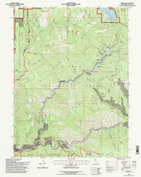
1994 Map of Caribou
USGS Topo · Published 1997About this map
North Fork Feather River carves a deep path through this portion of the northern Sierra Nevada, where industrial energy infrastructure meets gold-rush-era heritage. The landscape is defined by the transition from the high-elevation Butt Valley Res down to the river canyon, facilitated by the Intake Towers and Butt Valley Powerhouse. This drop in elevation supported a series of hydroelectric developments that fundamentally altered the drainage patterns of Butt Creek and its tributaries. Along the river banks, names like Rich Bar, Missouri Bar, and Indian Bar serve as markers of the area’s historic placer mining activity, while a small Cem near Rich Bar offers a poignant genealogical link to the pioneers of this river-and-rail corridor. The southern extent is protected within the Bucks Lake Wilderness, contrasting the heavily engineered utility sites of Caribou and the Belden Forebay with the pristine reaches of Serpentine Canyon.
Find a feature on this map
72 named features on this map. Tap any name to fly to it.
Don’t see what you’re looking for? This feature index may not catch every label — zoom into the map to look around manually.
Map Details
Editions of this 1994 Caribou Map
This is the sole edition of this map. No revisions or reprints were ever made.
Other maps of this area

1886 · Lassen Peak
USGS Topo · 1:250,000

1888 · Bidwell Bar
USGS Topo · 1:125,000

1891 · Bidwell Bar
USGS Topo · 1:125,000

1892 · Lassen Peak
USGS Topo · 1:250,000

1893 · Bidwell Bar
USGS Topo · 1:125,000

1894 · Lassen Peak
USGS Topo · 1:250,000

1895 · Bidwell Bar
USGS Topo · 1:125,000

1897 · Bidwell Bar
USGS Topo · 1:125,000

1950 · Bucks Lake
USGS Topo · 1:62,500

1955 · Almanor
USGS Topo · 1:62,500