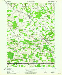
1943 Map of Carlisle
USGS Topo · Published 1964About this map
Cherry Valley Turnpike cuts a straight path across the southern portion of this landscape, anchoring the settlement of Carlisle during the early 1940s. The region is defined by a dense network of rural school districts and family burial grounds, reflecting a long-established agricultural society across the Root and Charleston townships. Significant local landmarks such as School No 11 and the Gove Cem near Rural Grove illustrate the community structure of the era. North of the turnpike, the terrain is shaped by the drainages of Yatesville Creek and Flat Creek, with poorly drained lowlands like Little Bear Swamp interrupting the upland farms. Genealogy researchers will find numerous named cemeteries including Lykers Cem and Friends Cem, which serve as vital markers of the families who populated these Montgomery and Schoharie County borderlands.
Find a feature on this map
35 named features on this map. Tap any name to fly to it.
Don’t see what you’re looking for? This feature index may not catch every label — zoom into the map to look around manually.
Map Details
Editions of this 1943 Carlisle Map
2 editions found
Other maps of this area

1896 · Fonda
USGS Topo · 1:62,500

1898 · Fonda
USGS Topo · 1:62,500

1898 · Canajoharie
USGS Topo · 1:62,500

1898 · Schoharie
USGS Topo · 1:62,500

1900 · Canajoharie
USGS Topo · 1:62,500

1900 · Schoharie
USGS Topo · 1:62,500

1900 · Schoharie
USGS Topo · 1:31,680

1902 · Canajoharie
USGS Topo · 1:62,500

1902 · Fonda
USGS Topo · 1:62,500

1904 · Richmondville
USGS Topo · 1:62,500