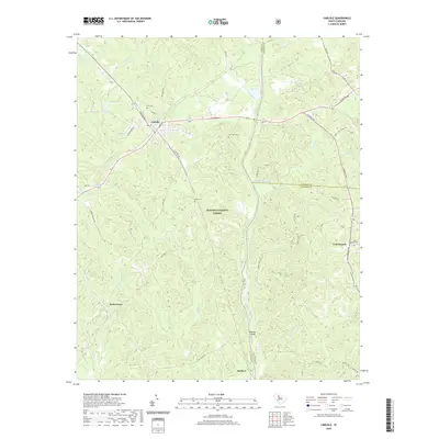
2020 Map of Carlisle
USGS Topo · Published 2020About this map
Carlisle serves as a central hub in this Upstate landscape, where the confluence of Union, Chester, and Fairfield counties meets along the winding Broad River. The terrain is defined by the extensive protected woodlands of the Sumter National Forest, which blankets much of the central and southern portions of the map. Traces of local heritage are visible in the scattered cemeteries, such as Hill Cem and Fish Dam Cem, alongside small rural settlements like Tuckertown and Cool Branch. The hydrography of the region is particularly dense, with numerous tributaries including the Sandy River, Brocks Cr, and Cane Cr feeding into the Broad. Notable landmarks like Shelton Island and family-named water bodies such as Gus Jeter Lake and Salinas Pond provide specific points of interest for those researching local land use and genealogy in this river-and-forest corridor.
Find a feature on this map
53 named features on this map. Tap any name to fly to it.
Don’t see what you’re looking for? This feature index may not catch every label — zoom into the map to look around manually.
Map Details
Editions of this 2020 Carlisle Map
This is the sole edition of this map. No revisions or reprints were ever made.
Other maps of this area

1904 · Columbia
USGS Topo · 1:125,000

1941 · Spartanburg
USGS Topo · 1:250,000

1953 · Spartanburg
USGS Topo · 1:250,000

1960 · Spartanburg
USGS Topo · 1:250,000

1963 · Spartanburg
USGS Topo · 1:250,000

1964 · Spartanburg
USGS Topo · 1:250,000

1969 · Whitmire South
USGS Topo · 1:24,000

1969 · Blair
USGS Topo · 1:24,000
1969 · Salem Crossroads
USGS Topo · 1:24,000
1969 · Carlisle
USGS Topo · 1:24,000