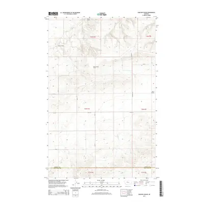
2014 Map of Carlson Coulee
USGS Topo · Published 2014About this map
Pondera Coulee and Carlson Coulee dominate the north-central topography of this North-Central Montana landscape, where the high plains of Chouteau County meet the southern boundary of Liberty County. The terrain is defined by a series of deep drainages, including Alkali Springs Coulee and Basin Coulee, which cut through the open country. This 2014 survey reveals a sparse, strictly organized grid of rural roads, such as Broadhurst Rd and Dugout Rd, which facilitate transport across the large-scale agricultural tracts and township sections that characterize this part of the state. The layout of the road network and the naming of the coulees reflect the historical reliance on these natural watercourses in an otherwise arid region.
Find a feature on this map
19 named features on this map. Tap any name to fly to it.
Don’t see what you’re looking for? This feature index may not catch every label — zoom into the map to look around manually.
Map Details
Editions of this 2014 Carlson Coulee Map
This is the sole edition of this map. No revisions or reprints were ever made.
Other maps of this area

1954 · Shelby
USGS Topo · 1:250,000

1958 · Shelby
USGS Topo · 1:250,000

1970 · Carlson Coulee
USGS Topo · 1:24,000

1970 · Knees NE
USGS Topo · 1:24,000

1970 · Uphill Creek
USGS Topo · 1:24,000

1970 · Knees
USGS Topo · 1:24,000

1970 · Pondera School
USGS Topo · 1:24,000
1970 · Russell Chapel
USGS Topo · 1:24,000
1970 · Mc Bridy Spring
USGS Topo · 1:24,000

1970 · Lothair SW
USGS Topo · 1:24,000