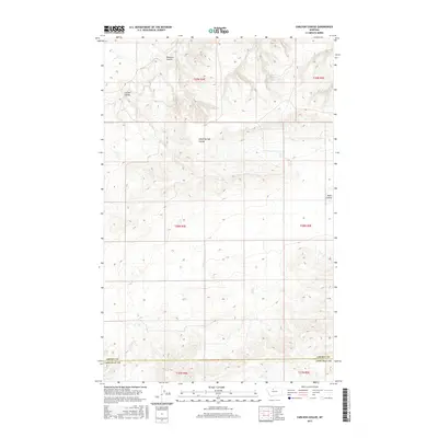
2017 Map of Carlson Coulee
USGS Topo · Published 2017About this map
The boundary line between Liberty and Chouteau counties cuts across this high plains landscape of north-central Montana. The terrain is defined by a series of drainage channels that carve through the section-line grid, most notably Pondera Coulee in the northwest and the winding Alkali Springs Coulee which dominates the central portion of the map. This area represents the open agricultural and grazing lands characteristic of the Big Sky Country, where the topographical relief is primarily concentrated within these deeply etched coulees. The map also traces the paths of Carlson Coulee and Basin Coulee, providing a detailed view of the water-carved geography that dictates the placement of roads and property boundaries in this rural landscape.
Find a feature on this map
15 named features on this map. Tap any name to fly to it.
Don’t see what you’re looking for? This feature index may not catch every label — zoom into the map to look around manually.
Map Details
Editions of this 2017 Carlson Coulee Map
This is the sole edition of this map. No revisions or reprints were ever made.
Other maps of this area

1954 · Shelby
USGS Topo · 1:250,000

1958 · Shelby
USGS Topo · 1:250,000

1970 · Carlson Coulee
USGS Topo · 1:24,000

1970 · Knees NE
USGS Topo · 1:24,000

1970 · Uphill Creek
USGS Topo · 1:24,000

1970 · Knees
USGS Topo · 1:24,000

1970 · Pondera School
USGS Topo · 1:24,000
1970 · Russell Chapel
USGS Topo · 1:24,000
1970 · Mc Bridy Spring
USGS Topo · 1:24,000

1970 · Lothair SW
USGS Topo · 1:24,000