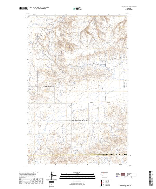
2024 Map of Carlson Coulee
USGS Topo · Published 2024About this map
Carlson Coulee and Alkali Springs Coulee carve through this landscape at the border of Liberty and Chouteau counties, defining a terrain of high plateaus and deep drainage channels. The map illustrates the sparsely settled ranching and dryland farming character of the region, where a geometric grid of section lines and gravel roads like Selma Rd and Broadhurst Rd provide the only infrastructure. The topography reveals the natural flow of water toward the south and east through Basin Coulee and Pondera Coulee, showing the literal contours of the high plains before they meet the Missouri River drainage system. It is a portrait of rural Montana where the land's utility is governed by the availability of water and the accessibility of isolated transport routes such as Dugout Rd.
Find a feature on this map
15 named features on this map. Tap any name to fly to it.
Don’t see what you’re looking for? This feature index may not catch every label — zoom into the map to look around manually.
Map Details
Editions of this 2024 Carlson Coulee Map
This is the sole edition of this map. No revisions or reprints were ever made.
Other maps of this area

1954 · Shelby
USGS Topo · 1:250,000

1958 · Shelby
USGS Topo · 1:250,000

1970 · Carlson Coulee
USGS Topo · 1:24,000

1970 · Knees NE
USGS Topo · 1:24,000

1970 · Uphill Creek
USGS Topo · 1:24,000

1970 · Knees
USGS Topo · 1:24,000

1970 · Pondera School
USGS Topo · 1:24,000
1970 · Russell Chapel
USGS Topo · 1:24,000
1970 · Mc Bridy Spring
USGS Topo · 1:24,000

1970 · Lothair SW
USGS Topo · 1:24,000