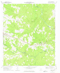
1972 Map of Carlton
USGS Topo · Published 1974About this map
The Broad River and its South Fork Broad River define this Madison County landscape, where the Seaboard Coast Line railroad serves as the primary industrial artery connecting Comer and Carlton (Berkeley Sta). The presence of Watson Mill and its associated Watson Mill Bridge State Park marks a significant historical convergence of industry and preservation along the riverbanks.
Find a feature on this map
39 named features on this map. Tap any name to fly to it.
Don’t see what you’re looking for? This feature index may not catch every label — zoom into the map to look around manually.
Map Details
Editions of this 1972 Carlton Map
This is the sole edition of this map. No revisions or reprints were ever made.
Other maps of this area

1891 · Carnesville
USGS Topo · 1:125,000

1893 · Elberton
USGS Topo · 1:125,000

1906 · Crawfordville
USGS Topo · 1:125,000

1953 · Athens
USGS Topo · 1:250,000

1954 · Greenville
USGS Topo · 1:250,000

1958 · Greenville
USGS Topo · 1:250,000

1958 · Athens
USGS Topo · 1:250,000

1958 · Danielsville
USGS Topo · 1:62,500

1958 · Elberton
USGS Topo · 1:62,500

1959 · Athens
USGS Topo · 1:250,000