
1948 Map of Carlyle
USGS Topo · Published 1948About this map
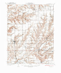
Carlyle serves as a central hub on this 1948 revision, where the Baltimore and Ohio RR intersects the Kaskaskia River. The landscape is defined by its complex hydrology, with numerous oxbow lakes such as Horseshoe Lake and Bear Lake lining the river's winding course. This era shows a densely settled rural landscape, evidenced by the high concentration of named country schools including The Mound School, Whites School, and Kell School.
Find a feature on this map
87 named features on this map. Tap any name to fly to it.
Don’t see what you’re looking for? This feature index may not catch every label — zoom into the map to look around manually.
Map Details
Editions of this 1948 Carlyle Map
This is the sole edition of this map. No revisions or reprints were ever made.
Other maps of this area

1906 · Breese
USGS Topo · 1:62,500

1907 · Breese
USGS Topo · 1:62,500

1910 · Carlyle
USGS Topo · 1:62,500

1910 · Okawville
USGS Topo · 1:62,500

1914 · Centralia
USGS Topo · 1:62,500

1931 · Hoyleton
USGS Topo · 1:48,000
1932 · Greenville
USGS Topo · 1:62,500
1932 · Nashville
USGS Topo · 1:62,500

1935 · Centralia
USGS Topo · 1:62,500
1936 · Nashville
USGS Topo · 1:62,500