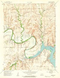
1957 Map of Carneiro
USGS Topo · Published 1958About this map
The Union Pacific railroad corridor anchors the northern reach of this mid-century Kansas survey, passing through the small community of Carneiro and near the Carneiro Cem. The landscape transitions from the upland drainage of Clear Creek and Thompson Creek toward the massive water management works to the southeast. Here, the Smoky Hill River feeds into the broad expanse of the Kanopolis Reservoir, a prominent feature that reshaped the local geography. Rural infrastructure is well-defined, with educational landmarks like School No 82 and Buckeye Sch serving the surrounding ranching and farming lands. The area's recreational and utility aspects are evidenced by the Girl Scout Camp and the Kanopolis Landing Field located along the reservoir's rugged shoreline at Yankee Run.
Find a feature on this map
13 named features on this map. Tap any name to fly to it.
Don’t see what you’re looking for? This feature index may not catch every label — zoom into the map to look around manually.
Map Details
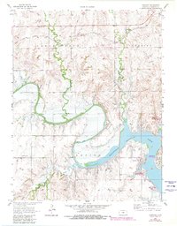
Editions of this 1957 Carneiro Map
2 editions found
Other maps of this area

1892 · Salina
USGS Topo · 1:125,000

1894 · Ellsworth
USGS Topo · 1:125,000

1942 · Salina
USGS Topo · 1:125,000

1955 · Great Bend
USGS Topo · 1:250,000

1955 · Hutchinson
USGS Topo · 1:250,000

1957 · Great Bend
USGS Topo · 1:250,000

1957 · Ellsworth
USGS Topo · 1:24,000

1957 · Westfall SW
USGS Topo · 1:24,000

1957 · Brookville SW
USGS Topo · 1:24,000

1957 · Westfall SE
USGS Topo · 1:24,000