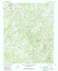
1959 Map of Carnesville
USGS Topo · Published 1986About this map
Carnesville serves as the focal point of this Northeast Georgia survey, which records the rural landscape between the 1950s and mid-1980s. The topography is defined by the bifurcating paths of the Middle Fork Broad River and the North Fork Broad River, which carve deep contours through Franklin County. Educational and spiritual life is anchored by institutions like Emmanuel College and several country churches including Liberty Ch, Gaines Chapel, and Zidon Ch.
Find a feature on this map
29 named features on this map. Tap any name to fly to it.
Don’t see what you’re looking for? This feature index may not catch every label — zoom into the map to look around manually.
Map Details
Editions of this 1959 Carnesville Map
Other maps of this area

1891 · Carnesville
USGS Topo · 1:125,000

1954 · Greenville
USGS Topo · 1:250,000

1958 · Greenville
USGS Topo · 1:250,000

1958 · Danielsville
USGS Topo · 1:62,500

1959 · Carnesville
USGS Topo · 1:24,000

1959 · Lavonia
USGS Topo · 1:24,000

1959 · Royston
USGS Topo · 1:24,000

1960 · Martin
USGS Topo · 1:24,000

1964 · Ila
USGS Topo · 1:24,000

1964 · Ashland
USGS Topo · 1:24,000