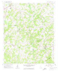
1959 Map of Carnesville
USGS Topo · Published 1974About this map
Carnesville serves as the focal point of this Franklin County landscape, where the North Fork Broad River and Middle Fork Broad River converge. The late 1950s terrain is marked by a dense network of country churches and family burial grounds, including Liberty Ch Cem near the Liberty Lookout Tower and Riverside Ch Cem along the river banks. In the southeastern corner, Franklin Springs is established as an educational and social hub, anchored by Emmanuel College and the neighboring town of Royston. The map provides a detailed view of the rural transition from the town center to the sprawling Victoria Bryant State Park, illustrating the importance of smaller communities like Sandy Cross and Canon in the local social geography. Notable recreational and religious landmarks like Poplar Springs Campgrounds reflect the era's community life and land use patterns.
Find a feature on this map
37 named features on this map. Tap any name to fly to it.
Don’t see what you’re looking for? This feature index may not catch every label — zoom into the map to look around manually.
Map Details
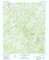
Editions of this 1959 Carnesville Map
Other maps of this area

1891 · Carnesville
USGS Topo · 1:125,000

1954 · Greenville
USGS Topo · 1:250,000

1958 · Greenville
USGS Topo · 1:250,000

1958 · Danielsville
USGS Topo · 1:62,500

1959 · Carnesville
USGS Topo · 1:24,000

1959 · Lavonia
USGS Topo · 1:24,000

1959 · Royston
USGS Topo · 1:24,000

1960 · Martin
USGS Topo · 1:24,000

1964 · Ila
USGS Topo · 1:24,000

1964 · Ashland
USGS Topo · 1:24,000