
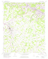
1959 Map of Lavonia
USGS Topo · Published 1961About this map
The Lavonia town center serves as the hub of this Northeast Georgia landscape, where the Southern Railway corridor links the community to Bowersville and beyond. The 1959 field survey captures a critical moment of transformation as the U.S. Corps of Engineers prepared for the inundation of the Tugaloo River valley. Blue hatching on the map indicates the anticipated shoreline of the Hartwell Reservoir, showing which low-lying lands along Gum Log Creek and Shoal Creek were slated for submergence at the 630-foot elevation.
Find a feature on this map
41 named features on this map. Tap any name to fly to it.
Don’t see what you’re looking for? This feature index may not catch every label — zoom into the map to look around manually.
Map Details
Editions of this 1959 Lavonia Map
2 editions found
Other maps of this area

1886 · Walhalla
USGS Topo · 1:125,000

1888 · Pickens
USGS Topo · 1:125,000

1891 · Carnesville
USGS Topo · 1:125,000

1892 · Walhalla
USGS Topo · 1:125,000

1893 · Elberton
USGS Topo · 1:125,000

1894 · Pickens
USGS Topo · 1:125,000

1896 · Walhalla
USGS Topo · 1:125,000

1954 · Greenville
USGS Topo · 1:250,000

1958 · Greenville
USGS Topo · 1:250,000

1958 · Fair Play
USGS Topo · 1:24,000