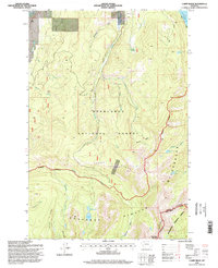
1996 Map of Carpp Ridge
USGS Topo · Published 1998About this map
Carpp Ridge and the high peaks of the Anaconda Pintler Range dominate this 1990s U.S. Forest Service revision, showing a landscape defined by the Continental Divide as it separates Granite Co and Deer Lodge Co. The terrain is marked by alpine basins and high-elevation waters including Carpp Lake, Spruce Lake, and the East Fork Reservoir. Evidence of high-country mineral exploration appears at the Carpp Mine and several unnamed prospects near the ridge, while the dense network of drainages like Mid Fk Rock Cr and Happy Creek illustrate the watershed's complexity. This map captures the transition from managed timber in the Deerlodge National Forest to the primitive landscape within the Anaconda Pintler Wilderness, where meadows such as McDougal Meadow and basins like Maloney Basin provided seasonal forage and passage in the era before modern recreational development intensified.
Find a feature on this map
41 named features on this map. Tap any name to fly to it.
Don’t see what you’re looking for? This feature index may not catch every label — zoom into the map to look around manually.
Map Details
Editions of this 1996 Carpp Ridge Map
This is the sole edition of this map. No revisions or reprints were ever made.
Other maps of this area

1908 · Philipsburg
USGS Topo · 1:125,000

1909 · Sapphire
USGS Topo · 1:125,000

1947 · Butte
USGS Topo · 1:250,000

1955 · Dillon
USGS Topo · 1:250,000

1957 · Dillon
USGS Topo · 1:250,000

1958 · Butte
USGS Topo · 1:250,000

1958 · Dillon
USGS Topo · 1:250,000

1960 · Butte
USGS Topo · 1:250,000

1962 · Butte
USGS Topo · 1:250,000

1962 · Dillon
USGS Topo · 1:250,000