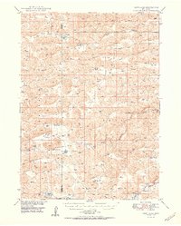
1950 Map of Carr Lake
USGS Topo · Published 1950About this map
The North Fork Dismal River winds through this cattle-country landscape on the border of Grant and Hooker counties. This mid-century survey illustrates the dispersed settlement pattern of the Nebraska Sandhills, where family-run operations like Carr Ranch, E Carr Ranch, and Riemer Ranch are centered near vital water sources. Education and community life were anchored by small, rural landmarks such as Erny Sch and Eclipse Sch, alongside the Eclipse Ch in the southeastern corner. The map also documents numerous windmills and flowing wells necessary for ranching across the Whitman Valley. Notable water bodies such as Carr Lake, Rosebud Lake, and Jefford Lake provide clear markers for genealogists and local historians tracing the exact locations of early twentieth-century homesteads and grazing lands.
Find a feature on this map
21 named features on this map. Tap any name to fly to it.
Don’t see what you’re looking for? This feature index may not catch every label — zoom into the map to look around manually.
Map Details
Editions of this 1950 Carr Lake Map
2 editions found

Other maps of this area

1947 · Dismal River Ranch
USGS Topo · 1:62,500

1948 · Carr Lake
USGS Topo · 1:62,500

1948 · Mullen
USGS Topo · 1:62,500

1948 · Whitman
USGS Topo · 1:62,500

1948 · Spring Valley
USGS Topo · 1:62,500

1949 · Arthur
USGS Topo · 1:62,500

1949 · Dismal River Ranch
USGS Topo · 1:62,500

1949 · Flats
USGS Topo · 1:62,500

1949 · Wright Valley
USGS Topo · 1:62,500

1950 · Flats
USGS Topo · 1:62,500