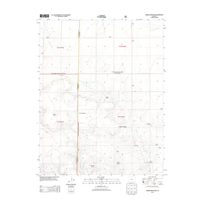
2013 Map of Carrizo Mountain
USGS Topo · Published 2013About this map
Comanche National Grassland dominates this high-plains landscape where the border of Las Animas and Baca counties meets. The terrain is defined by deep incisions in the earth, most notably Carrizo Canyon, Deep Hole Canyon, and Bushy Canyon, which provide drainage for intermittent waters like Cottonwood Cr and E Carrizo Cr. Human activity is sparse but centered on the life-giving waters of Carrizo Springs. Local history and genealogy are anchored at the Carrizo Springs Cem and the Everett Ranch, reflecting the enduring ranching character of this corner of Colorado. Distinctive landmarks such as Carrizo Mountain and Potato Butte rise above the surrounding flats, serving as navigational anchors in a region where isolated springs like Tub Spring were historically vital for livestock and settlement.
Find a feature on this map
26 named features on this map. Tap any name to fly to it.
Don’t see what you’re looking for? This feature index may not catch every label — zoom into the map to look around manually.
Map Details
Editions of this 2013 Carrizo Mountain Map
This is the sole edition of this map. No revisions or reprints were ever made.
Other maps of this area

1891 · Springfield
USGS Topo · 1:125,000

1892 · Mt Carrizo
USGS Topo · 1:125,000

1893 · Springfield
USGS Topo · 1:125,000

1955 · La Junta
USGS Topo · 1:250,000

1958 · La Junta
USGS Topo · 1:250,000

1968 · La Junta
USGS Topo · 1:250,000
1978 · Furnish Canyon East
USGS Topo · 1:24,000

1978 · Pintada Creek
USGS Topo · 1:24,000

1978 · Utleyville
USGS Topo · 1:24,000
1978 · Furnish Canyon West
USGS Topo · 1:24,000