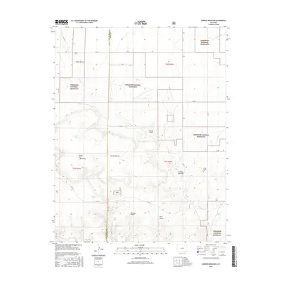
2016 Map of Carrizo Mountain
USGS Topo · Published 2016About this map
Carrizo Mountain and the surrounding high plains of the Comanche National Grassland dominate this landscape on the border of Las Animas and Baca Counties. The terrain is defined by dramatic mesas and erosion, including Potato Butte and Mt Carrizo, which give way to deeply carved drainages like Carrizo Canyon and Deep Hole Canyon. The settlement of Carrizo Springs is a primary focal point, situated near water sources that have long drawn inhabitants to this arid region. The presence of Tub Spring and the E Carrizo Cr suggest the vital importance of reliable water for ranching and homesteading. Local history is anchored at the Carrizo Springs Cem, while the section lines and rural road networks, such as Co RD Q and Co RD 34, trace the established grid of land use across this part of Southeast Colorado.
Find a feature on this map
33 named features on this map. Tap any name to fly to it.
Don’t see what you’re looking for? This feature index may not catch every label — zoom into the map to look around manually.
Map Details
Editions of this 2016 Carrizo Mountain Map
This is the sole edition of this map. No revisions or reprints were ever made.
Other maps of this area

1891 · Springfield
USGS Topo · 1:125,000

1892 · Mt Carrizo
USGS Topo · 1:125,000

1893 · Springfield
USGS Topo · 1:125,000

1955 · La Junta
USGS Topo · 1:250,000

1958 · La Junta
USGS Topo · 1:250,000

1968 · La Junta
USGS Topo · 1:250,000
1978 · Furnish Canyon East
USGS Topo · 1:24,000

1978 · Pintada Creek
USGS Topo · 1:24,000

1978 · Utleyville
USGS Topo · 1:24,000
1978 · Furnish Canyon West
USGS Topo · 1:24,000