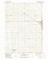
1980 Map of Carroll West
USGS Topo · Published 1980About this map
Middle Raccoon River winds through the central Iowa landscape, framing a region defined by agricultural townships and the growing western edge of Carroll. The area is characterized by a dense network of sectional roads and the prominent path of the Chicago and North Western railroad, which links the primary settlements of Maple River and Carroll. The map reveals the institutional foundations of these rural communities, with several denominational burial grounds such as St Francis Cem and Holy Angels Cem serving as local landmarks. From the elevation of Mount Moses to the residential streets near Maple Park, the document details the expansion of infrastructure, including numerous radio towers and civic boundaries like Washington and Roselle townships, illustrating the spatial organization of Carroll County during the late twentieth century.
Find a feature on this map
27 named features on this map. Tap any name to fly to it.
Don’t see what you’re looking for? This feature index may not catch every label — zoom into the map to look around manually.
Map Details
Editions of this 1980 Carroll West Map
This is the sole edition of this map. No revisions or reprints were ever made.
Other maps of this area

1954 · Omaha
USGS Topo · 1:250,000

1954 · Fort Dodge
USGS Topo · 1:250,000

1957 · Omaha
USGS Topo · 1:250,000

1957 · Fort Dodge
USGS Topo · 1:250,000

1958 · Omaha
USGS Topo · 1:250,000

1958 · Fort Dodge
USGS Topo · 1:250,000

1971 · Dedham
USGS Topo · 1:24,000

1971 · Templeton
USGS Topo · 1:24,000

1978 · Manning
USGS Topo · 1:24,000

1980 · Breda
USGS Topo · 1:24,000