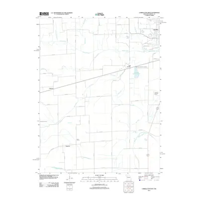
2012 Map of Carrollton West
USGS Topo · Published 2012About this map
Carrollton anchors the northeastern corner of this Missouri landscape, where the town's grid gives way to the intricate hydrology of the Missouri River floodplain. The area is defined by the winding course of Wakenda Creek and the meandering Moss Creek, which feed into various oxbows and managed waterways like the Sugartree Ditch. This 2012 survey illustrates a transition from the elevated town site down to the agricultural bottomlands, a terrain marked by numerous sloughs including Booker Slough and the descriptive Dirt Slough. Local history and genealogy are well-represented by several burial grounds, including Oak Hill Cemetery on the edge of town, Austin Cemetery near the former settlement of Sugartree, and the Sacred Heart Cemetery to the west. Transportation infrastructure is central to the area's layout, featuring the Carrollton Memorial Airport and the rail-oriented landmark of W B Junction, which sit near the recreational waters of Carrollton Recreation Lake.
Find a feature on this map
56 named features on this map. Tap any name to fly to it.
Don’t see what you’re looking for? This feature index may not catch every label — zoom into the map to look around manually.
Map Details
Editions of this 2012 Carrollton West Map
This is the sole edition of this map. No revisions or reprints were ever made.
Other maps of this area

1889 · Lexington
USGS Topo · 1:125,000

1890 · Marshall
USGS Topo · 1:125,000

1892 · Marshall
USGS Topo · 1:125,000

1901 · Marshall
USGS Topo · 1:125,000

1950 · Dover
USGS Topo · 1:24,000
1951 · Dover
USGS Topo · 1:24,000

1951 · Carrollton East
USGS Topo · 1:24,000
1951 · Standish
USGS Topo · 1:24,000

1951 · Waverly
USGS Topo · 1:24,000

1953 · Moberly
USGS Topo · 1:250,000