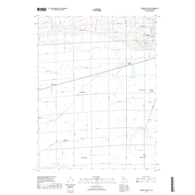
2017 Map of Carrollton West
USGS Topo · Published 2017About this map
Carrollton anchors the northeastern corner of this Carroll County landscape, where the town's residential grid transitions into the broad alluvial plains of the Missouri River valley. The hydrology is dominated by a complex network of wetlands and seasonal drainages, including Wakenda Creek and the long, winding Booker Slough. These natural features dictate the placement of transportation routes and smaller settlements like Palemon and Sugartree, the latter situated near the artificial drainage of the Sugartree Ditch.
Find a feature on this map
80 named features on this map. Tap any name to fly to it.
Don’t see what you’re looking for? This feature index may not catch every label — zoom into the map to look around manually.
Map Details
Editions of this 2017 Carrollton West Map
This is the sole edition of this map. No revisions or reprints were ever made.
Other maps of this area

1889 · Lexington
USGS Topo · 1:125,000

1890 · Marshall
USGS Topo · 1:125,000

1892 · Marshall
USGS Topo · 1:125,000

1901 · Marshall
USGS Topo · 1:125,000

1950 · Dover
USGS Topo · 1:24,000
1951 · Dover
USGS Topo · 1:24,000

1951 · Carrollton East
USGS Topo · 1:24,000
1951 · Standish
USGS Topo · 1:24,000

1951 · Waverly
USGS Topo · 1:24,000

1953 · Moberly
USGS Topo · 1:250,000