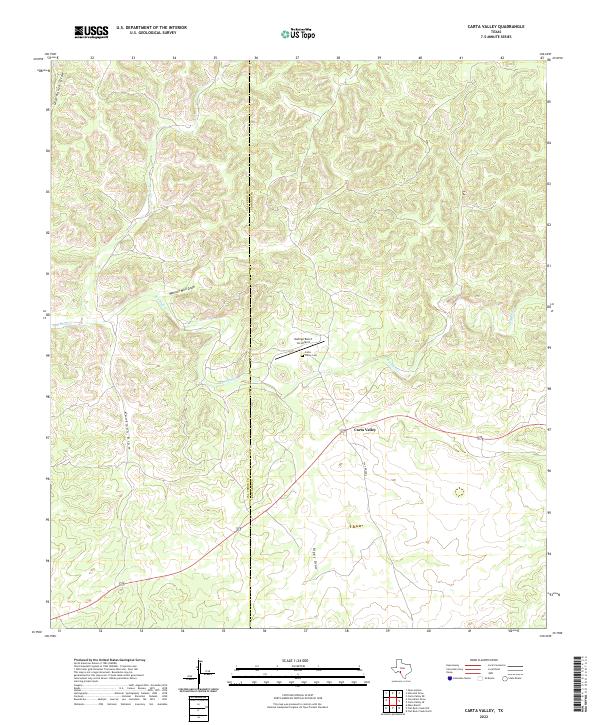
2022 Map of Carta Valley
USGS Topo · Published 2022About this map
Carta Valley serves as the central focal point for this Southwest Texas landscape, where the high desert terrain is defined by a complex network of seasonal drainages. The settlement's history is anchored by the Carta Valley Cem, while the Mafrige Ranch Inc Airport indicates the modern importance of private aviation in managing these expansive ranching properties. The physical geography is dominated by numerous dry washes, including Kaufman Draw, Wallace Well Draw, and Riggs Draw, which channel water toward the larger Red Bluff Cr. A prominent north-south boundary line divides the region between Val Verde County and Edwards County, bisecting the intricate contour patterns of the limestone plateau and its deeply carved draws.
Find a feature on this map
10 named features on this map. Tap any name to fly to it.
Don’t see what you’re looking for? This feature index may not catch every label — zoom into the map to look around manually.
Map Details
Editions of this 2022 Carta Valley Map
This is the sole edition of this map. No revisions or reprints were ever made.
Other maps of this area

1943 · Carta Valley
USGS Topo · 1:62,500

1944 · Flat Rock
USGS Topo · 1:62,500

1944 · Dry Devil
USGS Topo · 1:62,500

1944 · Devils Lake
USGS Topo · 1:62,500

1958 · Del Rio
USGS Topo · 1:250,000

1964 · Del Rio
USGS Topo · 1:250,000
1971 · Carta Valley NE
USGS Topo · 1:24,000

1972 · Miers Ranch
USGS Topo · 1:24,000
1978 · Holcomb Draw
USGS Topo · 1:24,000
1978 · Open Hollow
USGS Topo · 1:24,000