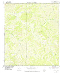
1978 Map of Holcomb Draw
USGS Topo · Published 1978About this map
The remote West Texas landscape along the Val Verde Co Edwards Co border is defined here by its complex drainage network and isolated ranching infrastructure in the late 1970s. The historic Mailtrail route and its associated Mailtrail Creek cut across the territory, serving as a primary corridor through the winding canyons. Water management is the central theme of this arid region, evidenced by the scattered distribution of man-made water sources including Potrock Well, Divide Wells, and the Lower Pasture Well.
Find a feature on this map
18 named features on this map. Tap any name to fly to it.
Don’t see what you’re looking for? This feature index may not catch every label — zoom into the map to look around manually.
Map Details
Editions of this 1978 Holcomb Draw Map
This is the sole edition of this map. No revisions or reprints were ever made.
Other maps of this area

1943 · Carta Valley
USGS Topo · 1:62,500

1944 · Dry Devil
USGS Topo · 1:62,500

1954 · Sonora
USGS Topo · 1:250,000

1958 · Sonora
USGS Topo · 1:250,000

1958 · Del Rio
USGS Topo · 1:250,000

1964 · Del Rio
USGS Topo · 1:250,000

1971 · Turney Draw SE
USGS Topo · 1:24,000
1971 · Carta Valley NE
USGS Topo · 1:24,000

1973 · Robinson Draw
USGS Topo · 1:24,000

1973 · Four Mills
USGS Topo · 1:24,000